Informasi satellite azimuth and zenith angle diperlukan sebagai input saat melakukan koreksi atmosferik, khususnya ketika menggunakan software simulasi 6S. (Penjelasan seputar koreksi atmosferik, akan diberikan pada tutorial terpisah)
Satellite zenith angle
Citra satelit Landsat 1 sampai Landsat 7 selalu memotret pada arah nadir, sehingga satellite zenith angle nya akan sama dengan 0°.
Mulai Landsat 8, satelite tidak selalu mengarah ke nadir, sehingga dalam metadata terdapat informasi seputar off-nadir, seperti di bawah
NADIR_OFFNADIR = "NADIR"
ROLL_ANGLE = -0.001
ROLL_ANGLE merupakan satellite zenith angle.
Satellite/View Azimuth Angle
Untuk menghitung azimuth dari satelit, kita bisa menggunakan dua koordinat yang ada di metadata:
Koordinat di pojok atas kiri:
CORNER_UL_LAT_PRODUCT = -1.84419
CORNER_UL_LON_PRODUCT = 120.73297
Koordinat di pojok atas kanan:
CORNER_LL_LAT_PRODUCT = -3.94598
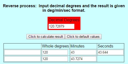
CORNER_LL_LON_PRODUCT = 120.72879
Ubah koordinat ke format DMS (Derajat, Menit, Detik), bisa menggunakan :
http://www.satsig.net/degrees-minutes-seconds-calculator.htm

Penghitungan azimuth dari dua koordinat (DMS), bisa menggunakan : http://www.fcc.gov/encyclopedia/distance-and-azimuths-between-two-sets-coordinates


Referensi:
http://gis.stackexchange.com/questions/91062/landsat-observation-zenith-and-azimuth-angles
Post Disclaimer
The information contained in this post is for general information purposes only. The information is provided by Sudut Azimuth dan Zenith Satelit Landsat 8 and while we endeavour to keep the information up to date and correct, we make no representations or warranties of any kind, express or implied, about the completeness, accuracy, reliability, suitability or availability with respect to the website or the information, products, services, or related graphics contained on the post for any purpose.